The walks happened about forty miles from our house.
We encountered odd, unique, and powerful sights and sounds.
They happened on two weekends last summer.
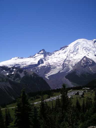
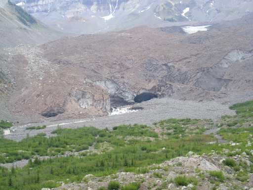
This pic was taken on the first weekend. In the pic, at the end of the glacier, (which is under dirt at that point), is the exit cave. You can barely see it. We decided to have a look at this cave the next week.
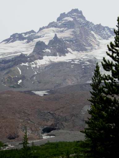
Rainier is on the right, Little Tahoma Peak on the horizon in the center. Years ago (December, 1963) 14 million cubic yards of rock left Little Tahoma peak and came straight toward the camera, down the glacier on the right of Little Tahoma. It may have been prompted by a steam explosion. Little Tahoma does that occasionally.
No one saw it because Rainier NP is closed in winter, but skiers about 20 miles away heard the rumbling. The rocks continued 4 miles on down the valley and ended up near the White River campground. Luckily no one was camped there in the middle of winter.
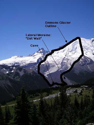
Here's the key. Compare it with the previous picture.
The "dirt wall," a lateral moraine, was hard to climb back up. Where we climbed it, it was full of rocks & a few trees, and about 150 feet high. It's composed mainly of powdery volcanic ash.
Altitude at the cave is around 4500 feet. Altitude of the mountaintop is 14400+ feet.
The lower 25% of the glacier, as you can see, is still covered with rocks and dirt.
Telephoto pic of cave. Also our car is in the picture. Right there. The dark blue one.
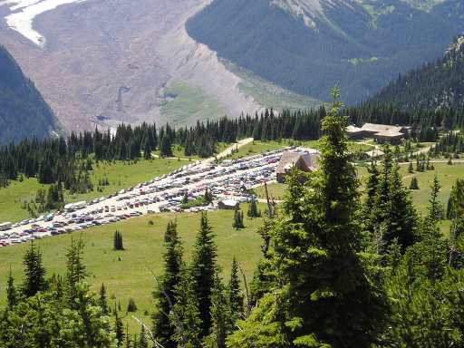
This is the "Sunrise" parking lot at Mt. Rainier NP.
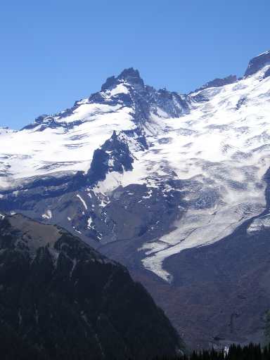
Telephoto pic of cave, glacier, & Little Tahoma Peak. This is the last picture taken on the "good picture" weekend.
Evidently the dirt covering the lower end of the glacier is almost entirely from the rockfall of 1963. The bigger rocks (some the size of houses, I've read) went on down the valley. The dirt & small stuff stayed on the glacier.

OK, it's a week later, we're at the entrance to White River Campground. This cheerful sign greets us. I guess the NPS doesn't want to be responsible if the mountain decides to bury us.
Notice only campers are warned. Hikers can be as foolhardy as they wish, evidently. We didn't camp. We hiked.
We actually took this picture many weeks after the other pictures. It wasn't yet relevant to us when we drove in on the day of the hike. . .
We're at the top of the "dirt wall" moraine with a telephoto lens. Everything between the cave and the snowfield directly above it is dirt-covered glacier - also above the snowfield for a little way.
Little Tahoma at the top. Can you imagine 14 million cubic yards of rock coming at you down this slope?
Click here to display an interesting read all about it. (It will open in a new window.)
Little Tahoma is being undercut by glaciers on both sides, and it gets steeper and pointier with every rockfall, as the glaciers scrape away at it. Actually, "Little Tahoma" is a big mountain. I believe it's over 10,000 feet high. It's just dwarfed by its much bigger neighbor.
We're most of the way down to the valley bottom, although it looks like we're still high. From here to the cave was all glacial debris, up & down rockpiles, dirt, bad footing - a rather miserable walk. That rock ridge across the bottom of the picture has a 25 foot drop down the other side - all slidey dirt, big rocks, and holes.
Dirt that's on top of ice is brown. Dirt without ice underneath is gray. Walls of exposed ice are gray.
Almost there. Actually it was another 30 minutes climbing over those messy rocks.
A few minutes before this picture was taken, there was a huge snow crash in the area of the far left side of the picture. The snow wall there was about 40 feet high, and a huge section came down. Lots of noise.
An 11 year old kid and his dad from NY were with us until that point. Spooked the kid. They didn't go much farther.
It -was- rather spooky. Rocks were falling off the ice walls every few minutes - some of them big ones. The river was roaring constantly, and sometimes, if you were looking in the right place at the right time, you could see movement, but couldn't hear it over the noise of the river. Every minute or so, on average, a half pint (minimum) of dirt would fall from the edge in a single cascade.
Earlier, on the way down the dirt wall, we heard the glacier emit a terrific boom - sounded like a cannon shot - but by the time we looked, we couldn't see any movement anywhere. The sound took a long time to get to us, I suppose.
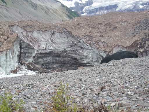
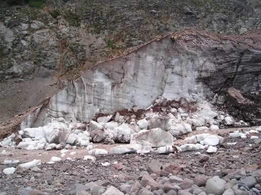
The wall where the fall happened. The ice cave is just to the right, out of the picture.
This is the fall wall, up close. These ice blocks are about 30 minutes old.
Notice how thin the dirt layer is on top of the glacier.
It's the rocks up there that kept falling, both here and across the entire ice face - including directly over the cave.
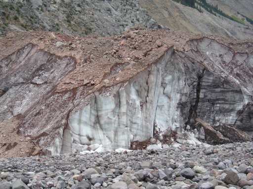
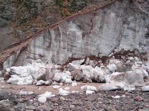
More "fall wall," wide angle lens. The big ice cube front & center is taller than us. Notice - it's on OUR side of the river!
Wall is about 50 feet high at its highest point, I'm guessing.
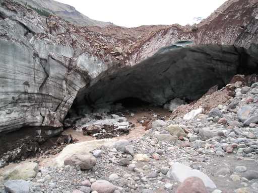
The object of the trip: the cave, which is about 60-70 feet wide. Camera is actually pointed down, using wide angle lens because we're rather close. We're roughly level with the top of the cave. The river is boiling out of that black hole at the back of the cave. (boiling? - I actually suspect it was rather chilly. We saw no need to check the temperature.) After witnessing the big ice fall, it was unnerving being this close.
Just in front of us is a steep drop down to the river. Nice brown river, rocks & dirt dropping everywhere from the top edge - and if we weren't careful where we stepped, we would find glacier also under our feet, under the rocks & dirt.
Notice all the dirt dribbles along the edge of the ice. The river was so noisy that we couldn't adequately hear the noise caused by dirt & rocks moving at the edge - and it was constantly moving. While framing up this picture, there was a huge KLONK! about 60 feet to my left at the "fall wall." We snapped our heads around just in time to watch a big one come to a full stop. It was 2-4 feet wide and had fallen about 50 feet onto another rock. Maybe 350 lbs? Really gets your attention. We didn't stay here very long.
Cave scuba diving, anyone?
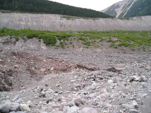
Here's the actual foot of the glacier. Can't see any ice, but you can tell where the ice is buried because the dirt is brown & wet. (Dry dirt is gray.) The "fall wall" is behind the camera, so we're actually between the glacier's toes.
Emmons is an advancing glacier, not a retreating one, mainly because of all the dirt that got dumped on it 40 years ago. The dirt insulates the ice, if it's thick enough. About an inch is enough, I understand.
The advance has slowed in the last 15 years because the terminus is reaching lower & lower altitudes. This means not only warmer air, but slightly warmer rain in the summer. (We're talking hundredths of a degree here.)
Sooner or later the glacier will shed all of its insulating rocks and the terminus will retreat back up the mountain. At the rate it's going, that may be 200 years, or it may be much sooner.
In the seventh picture (click here to go back up and see it again) you can see the surface of the lower glacier is getting very hummocky. This is due to uneven melting rates caused by streams underneath (or lack thereof), thickness of rock & dirt on top, and some recent hot summers.
In the fourth picture (click here to go back up and see it again) you notice the white tongue coming down the center of the glacier. Emmons Glacier, like almost all glaciers, moves fastest at its centerline, and when the white tongue meets the terminus (the cave), the retreat will begin.
The white center will retreat first because of the lack of insulating dirt on top. This will leave an "ice ditch" with big dirt-topped ice walls on either side. Should be interesting - but the chances of us still being around to see it are slim, unless the weather gets really weird.
Back to this last picture. In the pic background is the infamous dirt wall, the lateral moraine. The place we climbed it is off to the right, not pictured.
Sometimes on hot days ice dams up high up on the mountain under the glaciers actually fail, and these channels you see here have flash floods, or "glacial outburst floods."
A big one on a very hot day a few years ago made Science News. (It was on the other side of the mountain - not at this site.) It scared away the audience at a Ranger lecture when a normally dry channel behind the lecturing Ranger suddenly started roaring. There must have been a lot of mud - it sent a huge and highly visible mud plume out into Puget Sound at the Port of Tacoma the next day.